.png)
 German (DE)
  English (US)
  Spanish (ES)
  French (FR)
  Hindi (IN)
  Italian (IT)
  Russian (RU)
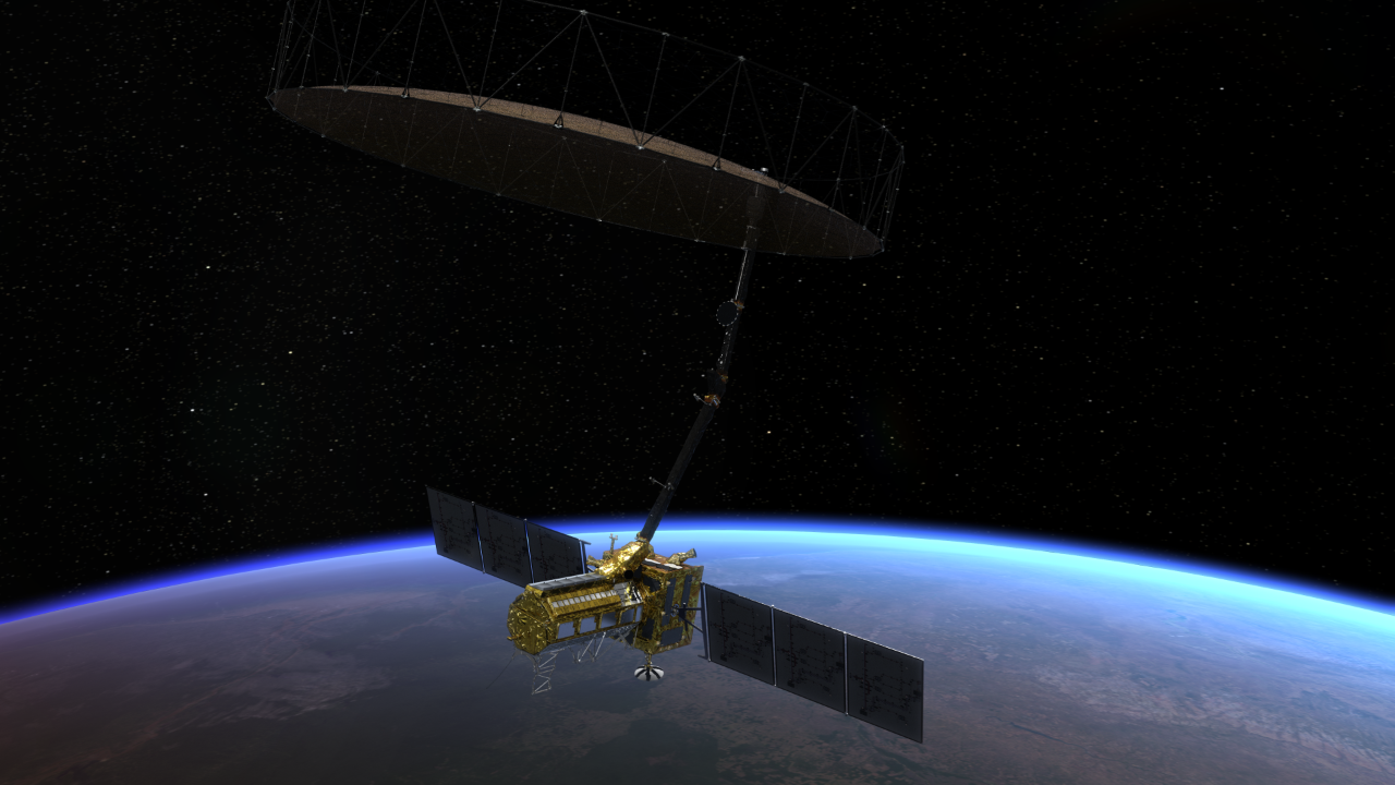
The first equal partnership between NASA and the Indian Space Research Organisation (ISRO) is set to take flight on July 30 with the launch of the NISAR Earth-observation satellite.
Standing for NASA-ISRO Synthetic Aperture Radar, NISAR will scan our planet to provide the most detailed map of the surface yet, and the most sensitive, able to see the ground or ice creeping by degrees of less than a centimeter.
This sensitivity, as well as the overall coverage of Earth that NISAR will provide, will be essential for helping to avert, or minimize, the effects of natural disasters, from earthquakes and volcanoes to land subsidence and swelling, plus the movement, deformation and melting of ice sheets and glaciers, and the tracking of wildfires and floods. Even the smallest shifts in the landscape could one day prove to be the precursor to a major disaster. For example there are "slow" landslides, where a mountainside or cliff might move by just a few centimeters per day, before reaching a tipping point and crashing down. NISAR will be able to see that slow creep, or the subtle movement of tectonic plates, and warn when more serious disasters might be about to take place.
"Where moments are most critical, NISAR's data will help ensure the health and safety of those impacted on Earth as well as the infrastructure that supports them," said Nicky Fox, associate administrator of NASA's Science Mission Directorate, in an agency press conference on July 21.
"They can be very small changes, but they can have enormous implications," added Karen St. Germain, the director of NASA's Earth Science Division.
NISAR will achieve this thanks to its dual-frequency band radar. The L-band radar, which transmits microwaves between 1 and 2 gigahertz (GHz), was built by NASA's Jet Propulsion Laboratory (JPL) in Southern California, while ISRO provided the S-band radar operating between 2 to 4 GHz. The different frequencies can detect different things on the ground. The S-band is sensitive to vegetation and foliage, for example, whereas the L-band can see through the trees to monitor the bare surface, be that rock or ice. And because neither instrument is encumbered by clouds, the coverage of the surface is total, mapping the entire globe in unprecedented detail every 12 days.
"These two radars work together to accomplish science that neither can see on their own," said Wendy Edelstein, who is NISAR's deputy project manager at JPL.
Both radars feed into NISAR's giant antenna, which is 12 meters (about 40 feet) in length; when unfolded, it's about the size of a tennis court. "The surface material is a lightweight mesh that allows the whole antenna to fold very compactly and be stowed for launch," said Edelstein.
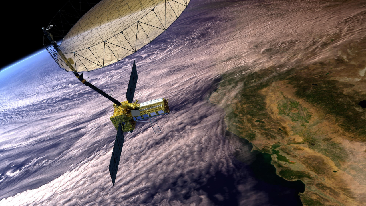
It's this antenna that gives NISAR its special powers of high resolution, thanks to a technique called synthetic aperture radar.
Synthetic aperture radar takes advantage of the fact that NISAR is moving. The spacecraft beams down radar pulses while flying along, and because of this motion, the area on the ground covered by each radar beam while switched on is about 10 kilometers (6 miles) long. This is far larger than the actual size of the antenna on the spacecraft — hence why it's called synthetic aperture radar. Ordinarily, this motion would incur a motion blur, but by beaming thousands of radar pulses per second to capture the fine detail, NISAR is able to see in high resolution.
"We sort of build up a movie, frame by frame, of every point on the Earth's surface," said Paul Rosen, who is NISAR's project scientist at JPL.
By flying in an exact-repeat orbit — meaning it passes over the exact same ground track, every 12 days in this case — NISAR will be able to combine its synthetic aperture radar with another technique called radar interferometry
"We fly along, collect the echoes, make the image, and come back again at a later time and make another image, and count the peaks and troughs of the radar waves and use them as a yardstick to measure how the ground is moving over time," said Rosen.
NISAR will head into space on July 30 on board an Indian Geosynchronous Satellite Launch Vehicle (GSLV) rocket from ISRO's Satish Dhawan Space Center in Sriharikota, which is on India's southeastern coast.
"NISAR is an equal 50/50 partnership between NASA and ISRO," said Edelstein. Fox stated that NASA had spent $1.2 billion on the mission, in particular funding the L-band radar, plus the antenna and its boom. ISRO contributed the S-band transmitter, the spacecraft bus, solar arrays and the launch vehicle.
None of the Indian contingent on the project were in the press conference — because of time zone differences, according to NASA. However, in January, the co-lead of the ISRO science team at the Space Applications Centre in Ahmedabad, Deepak Putrevu, said in a statement. "This mission packs in a wide range of science toward a common goal of studying our changing planet and the impacts of natural hazards."
Ten days after launch, NISAR will be in position to begin unfurling its giant antenna, and by day 65 the first full-frame science images will be produced.
"I've spent my entire career working on radar missions for JPL, and NISAR is the highlight for me," said Edelstein. "I can't wait to see the science that it produces and the impact that it has. I think it will help people around the world."


Comments